


2022-02-06_18h05m52_Trebas Combradet 18km

tercla
User
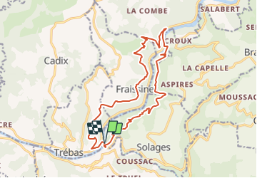

Length
18.3 km

Max alt
459 m

Uphill gradient
694 m
Km-Effort
28 km

Min alt
212 m

Downhill gradient
702 m
Boucle
Yes
Creation date :
2022-02-06 17:05:52.887
Updated on :
2022-02-11 06:17:39.408
6h16
Difficulty : Medium

FREE GPS app for hiking
 SityTrail
IGN / Geographical institutes
SityTrail Plus
The world is yours!
About
Trail On foot of 18.3 km to be discovered at Occitania, Aveyron, La Bastide-Solages. This trail is proposed by tercla.
Positioning
Country:
France
Region :
Occitania
Department/Province :
Aveyron
Municipality :
La Bastide-Solages
Location:
Unknown
Start:(Dec)
Start:(UTM)
459895 ; 4866029 (31T) N.
Comments